Scotland’s roads are not for the unprepared (or for those who cannot reverse) with single tracks with hair pin bends and unexpected wildlife in the road. However, to see the most awe inspiring parts of Scotland you need to get behind the wheel and off the beaten track.
I’ve driven all over Scotland seeking out the roads with the most awe inspiring views – many of our roads are contenders for the most beautiful road in the world! These roads aren’t multi-day road trips with itineraries and accommodation stops, but individual roads where the experience of driving them is the entire point.
Here are fifteen scenic Scottish drives I’d recommend you to drive, with a few honest warnings about which ones are not for the faint-hearted, the ones campervans should avoid, and the ones that close in winter.
If you’re looking for multi-day road trip itineraries (the NC500, the NE250, etc), see my Scotland road trips guide. This post is about the individual roads.
Let’s go.
The best drives in Scotland for:
What you need to know before you go
A few honest things worth knowing about Scottish driving roads:
- Single track is the rule, not the exception. Outside the motorways and main A roads, expect single-lane carriageway with passing places. Use them properly. Pull in for oncoming traffic and let faster cars behind you past. The locals will love you for it.
- Phone signal is patchy. Download offline maps before you set off. Google Maps stops working in entire valleys, particularly Wester Ross and Knoydart.
- Plan for 30 mph average, not 50. Single-track roads, weather, sheep, photo stops and slow caravans will all halve your driving speed. A 100-mile drive in the Highlands often takes 3 to 4 hours.
- Some of these roads close in winter. The Snow Roads have earned their name. The A939 Cock Bridge to Tomintoul is the most-closed road in Scotland. Check before you set off November to March.
- Fuel up before you go remote. Some of these drives have no petrol stations for 50+ miles. Top up at the start.
1. Bealach na Bà to Applecross
- Distance: 11 miles
- Time: 30 to 45 minutes (without stops)
- Best for: the wow factor, hairpin bends, dramatic scenery
- Watch out for: sheer drops, no run-off, motorhomes (they shouldn’t be on this road)
- Don’t miss: the viewpoint at the top
- Where to eat: the Applecross Inn at the end (book ahead)
The headline drive of the Highlands and probably the most dramatic public road in Britain. Bealach na Bà rises from sea level at Tornapress to 626 metres in 6 miles of switchback hairpins, then drops back down to the village of Applecross on the other side of the peninsula.
It’s properly steep (1 in 5 in places), genuinely single-track, and on a wet day with cloud sitting on the pass it can feel like a Highland version of an Alpine driving road. Not for nervous drivers. Not for large motorhomes despite what your hire firms tells you.
The reward is the view from the top across to Skye, Raasay and the Outer Hebrides on a clear day, and the village of Applecross at the end with one of Scotland’s best pubs.
If conditions look poor, the alternative coast road from Shieldaig is longer but considerably easier.
Read more: things to do on the Applecross Peninsula.
2. The drive to Kinloch Hourn
- Distance: 22 miles one way
- Time: 1.5 hours each way (without stops)
- Best for: Britain’s longest dead end, fjord-like loch views
- Watch out for: the final descent (genuinely steep), no turning until the end
- Don’t miss: the Loch Quoich dam, the views back to the Glen Shiel ridge
- Where to eat: Lochhournhead B&B and Tea Room at the end
Described as Britain’s longest dead-end road, the drive down to Kinloch Hourn (also marked on maps as Lochhournhead) is 22 miles of rather hair-raising single track.
The road leaves the A87 at Glengarry, signposted to Tomdoun and Kinloch Hourn. It takes you along Loch Garry to Loch Quoich and the massive Glen Garry hydroelectric dam. With the Munros of Gleouraich and Spidean Mialach rising above you, the road winds along the steep hillside before descending to one of Scotland’s most remote settlements.
The very last section is something else. Steep, twisting, with passing places that don’t quite work for the gradient. Not a road for a campervan. The kind of drive you remember for years.
From Kinloch Hourn you can hike along the loch to Barrisdale Bay or deeper into Knoydart.
Read more: visiting Kinloch Hourn.
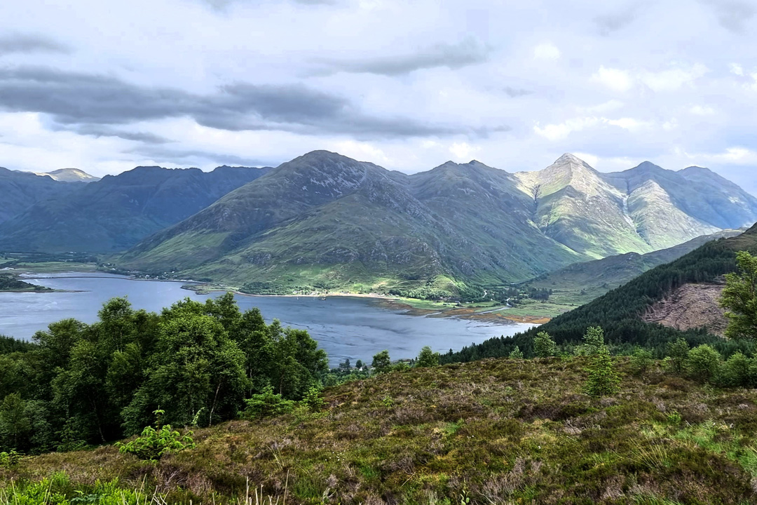
3. The Mam Ratagan Pass to Glenelg
- Distance: 10 miles
- Time: 30 minutes
- Best for: views to Skye, the Five Sisters of Kintail
- Watch out for: the steep climb up Mam Ratagan in a motorhome
- Don’t miss: the two viewpoints on the pass, the turntable ferry to Skye
- Where to eat: The Glenelg Inn
Across the Kyle Rhea strait from Skye is the Glenelg peninsula and accessed across the dramatic 1,112ft Mam Ratagan pass and 10 miles of single track road, the route to Glenelg starts at Shiel Bridge.
The views from the top of Mam Ratagan looking back down Loch Duich to the Five Sisters of Kintail are extraordinary, mimicking the fjords of New Zealand’s South Island. From the top of the pass, the drive down to Kirktown of Glenelg is somewhat easier but no less beautiful.
Glenelg has the turntable ferry to Skye (the last manually operated turntable ferry in the world), the 2000 year old Dun Telve and Dun Troddan brochs, and otters at Sandaig (the bay where Gavin Maxwell wrote Ring of Bright Water).
Read more: driving the Mam Ratagan pass.
4. The Snow Road (A93 over the Cairngorms)
- Distance: 32 miles, Glenshee to Braemar
- Time: 1 hour
- Best for: the highest public road in Britain
- Watch out for: snow closures October to April
- Don’t miss: The Cairnwell at the top, sunrise over the pass
- Where to eat: the Glenshee Ski Centre Cafe, or carry on to Braemar
Britain’s highest public road, the A93 from Glenshee to Braemar tops out at the Cairnwell pass at 670 metres. On a clear day it’s spectacular. On a cloudy one it’s atmospheric. In a snowstorm it’s terrifying.
The drive runs through the eastern Cairngorms, with the Cairnwell ski area at the top of the pass and the Royal village of Braemar on the other side. The southern half drops down through Glen Shee with the river running alongside the road. The northern half opens out into Royal Deeside.
Worth doing at sunrise if you can. The light on the eastern Cairngorms is exceptional.
This is the start of the North East 250 and one of Scotland’s quintessential mountain drives. Check the forecast in winter.
5. Strontian to Sanna Bay
- Distance: 32 miles one way (after the Corran Ferry)
- Time: 2 hours each way
- Best for: wildlife, temperate rainforest, the most westerly road on the British mainland
- Watch out for: wildlife on the road, the Corran Ferry not running
- Don’t miss: Ardnamurchan Lighthouse, Sanna Bay, Ardnamurchan Distillery
- Where to eat: the Kilchoan Hotel or Salen Hotel
“A roads” in Scotland are considered to be the major roads, but that is until you reach the Highlands where an A road can often have grass growing down the middle at worst and be single track at best. One of my favourite single-track A-roads is the drive from Strontian to Sanna across the West Highland Peninsulas.
To get to Sanna you first have to cross Loch Linnhe on the Corran Ferry. Leave the tiny hamlet of Ardgour behind and follow the single-track road west along Loch Sunart (Scotland’s longest sea loch) to Moidart and then on to Ardnamurchan through Glenborrowdale.
The road passes through remnants of temperate rainforest, beautiful oak woodlands, and across a volcanic caldera. The landscapes of Ardnamurchan are over 60 million years old.
Don’t miss a visit to Ardnamurchan Lighthouse, Scotland’s most westerly point where you can watch whales and dolphins pass by. A stroll at Sanna Bay with its views of An Sgùrr and the Rum Cuillin. A visit to Ardnamurchan Distillery, Scotland’s most westerly distillery.
The Ardnamurchan Peninsula is home to red squirrels, red deer, otters, and I’ve even seen wild boar on the road to Sanna. The Corran Ferry can be a bit hit and miss, so check it’s running. It’s a long way round via Fort William if the crossing across Loch Linnhe isn’t going.
Read more: Ardnamurchan and the West Highland Peninsulas.
6. The Loch Ard road, Aberfoyle to Inversnaid
- Distance: 17 miles
- Time: 45 minutes
- Best for: an underrated drive, views of Ben Lomond from the back
- Watch out for: ice in winter, this is a remote road
- Don’t miss: the view down Loch Arklet to Loch Lomond
- Where to eat: the Inversnaid Hotel at the end (if open)
The bonnie banks of Loch Lomond are usually visited from the busy A82 on the loch’s western edge, but some of the best views are from this quiet B-road from Aberfoyle to Inversnaid.
Leaving Aberfoyle, the B829 hugs the side of Loch Ard with its stunning and unusual view of the back of Ben Lomond. Becoming more and more remote, the road passes Loch Chon before reaching the end of Loch Arklet, revealing one of my favourite views in Scotland.
The last stage of your drive takes you down to Inversnaid and the eastern banks of Loch Lomond. The Inversnaid Hotel sits right on the loch and you can pick up the West Highland Way for a stroll along the water.
A genuinely overlooked drive. Don’t tell anyone.
7. The Three Lochs Forest Drive, Aberfoyle
- Distance: 7 miles
- Time: 1 hour (mostly unpaved)
- Best for: a slow, relaxing drive in the Trossachs
- Watch out for: stones and rocks, cyclists, walkers, red squirrels
- Don’t miss: a walk down to Loch Achray or Loch Drunkie
- Where to eat: the Forth Inn or Scottish Wool Centre cafe in Aberfoyle
The beautiful 7-mile Three Lochs Forest Drive visits Lochan Reòidhte, Loch Drunkie and Loch Achray, taking you over the steep Duke’s Pass.
Just 7 miles long but packing in the views, the Three Lochs Forest Drive is open to cars between March and October (walkers and cyclists all year round) and has a charge of £2 to enter. The route is one way and starts on the east side of the Duke’s Pass (A821), about 2 miles north of Aberfoyle.
Most of the forest drive is unpaved, so this is the slowest of my Scotland driving routes, but probably the most relaxing. If you want to stay overnight, there are lots of camping spots by the lochs, although you’ll need a permit.
There’s a short trail to follow at Loch Achray (¾ of a mile) and a longer one at Loch Drunkie (1.5 miles).
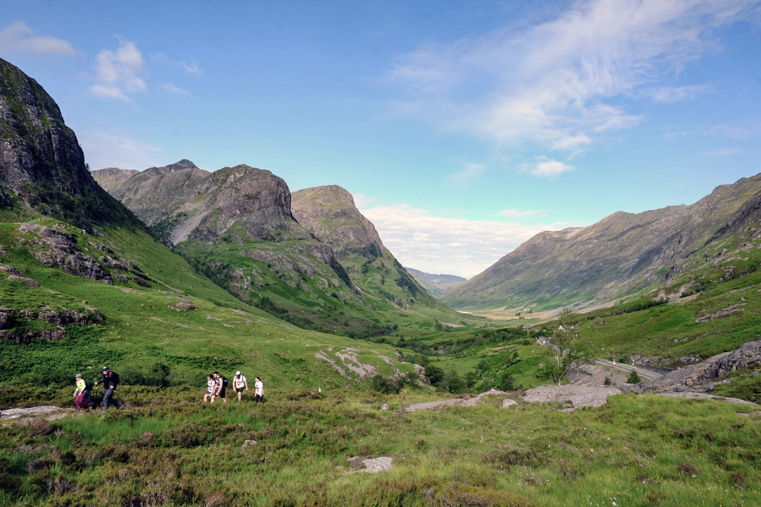
8. Glencoe on the A82
- Distance: 17 miles
- Time: 30 minutes
- Best for: the most photographed glen in Scotland
- Watch out for: bad driving, summer parking
- Don’t miss: the Three Sisters viewpoint, the Pap of Glencoe
- Where to eat: the Clachaig Inn
No visit to Scotland is complete without a drive through the spectacular Glen Coe as it winds its way from Rannoch Moor.
Drive past the monolithic Buachaille Etive Mòr and Beinn a’ Chrùlaiste, past the famous “wee white hoose”, under the dramatic Aonach Eagach ridge (the narrowest ridge in the UK), to the Three Sisters (Beinn Fhada, Gearr Aonach and Aonach Dubh). It is a classic Scotland road.
It’s not a remote drive (this is the main road) but it earns its place in any list of Scotland’s best drives because the scenery is simply that good. Two miles into the drive from Rannoch Moor you’re already taking photos.
Don’t miss a walk around the beautiful Glencoe Lochan, finding the Lost Valley (Coire Gabhail), climbing the Pap of Glencoe, or visiting the Glencoe Folk Museum. Take a detour down Glen Etive (yes, the Skyfall road).
Watch out for bad driving. Lots of locals (and visitors too) get frustrated by the slow speeds through the glen and overtaking is rife. The parking situation in the glen is also informal in places and in the summer months can be tricky.
Read more: things to do in Glencoe.
9. The Etive road, Glen Etive
- Distance: 14 miles one way
- Time: 45 minutes each way
- Best for: James Bond Skyfall scenery
- Watch out for: dead end road, return the way you came
- Don’t miss: the Skyfall layby, the river pools (wild swimming spots)
- Where to eat: nothing on the road, eat at the Kingshouse on the A82 first
Turn south off the A82 just east of Glencoe and you’re on the road to Glen Etive. The single-track road follows the River Etive for 14 miles down to the head of Loch Etive at the end.
The scenery is iconic. This is the road that featured in the opening sequence of Skyfall, with Daniel Craig’s Aston Martin parked overlooking the glen. Even without the Bond association, the drive down Glen Etive is one of the most beautiful in Scotland. The river is full of pools deep enough for wild swimming on a hot day.
It’s a dead-end road, so you drive in and you drive back out. Allow 2 hours minimum for the round trip.

10. The Achiltibuie coast road
- Distance: 23 miles loop
- Time: 1.5 hours
- Best for: the most beautiful section of the NC500
- Watch out for: single-track for the entire loop
- Don’t miss: Stac Pollaidh from the road, the Summer Isles view
- Where to eat: the Am Fuaran Bar at Altandhu
The detour off the NC500 most people miss. The single-track loop from Drumrunie to Achiltibuie and back via Lochinver passes through what I genuinely think is the best scenery in mainland Scotland.
You drive directly underneath Stac Pollaidh, one of the most distinctive small mountains in Scotland. You skirt the edge of Loch Lurgainn, you wind along the coast looking out at the Summer Isles, you pass through the small crofting villages of Achiltibuie, Altandhu and Reiff. The road eventually rejoins the NC500 just north of Lochinver.
Add it to any NC500 trip. It’s a half-day extension that doubles the quality of your trip.
Read more: things to do in Lochinver and Assynt.

11. The Drumbeg Loop, “the NC500’s mad wee road”
- Distance: 14 miles
- Time: 1 hour
- Best for: twisty single-track, beaches, the wildest stretch of the NC500
- Watch out for: blind hairpin bends, other drivers, oncoming traffic on blind summits
- Don’t miss: Achmelvich Beach, Clashnessie Falls, the Drumbeg viewpoint
- Where to eat: the Kylesku Hotel at the end (book ahead, you’ll have earned it)
If you’re looking for a technically difficult but absolutely stunning Scotland driving route, then the mad wee road (otherwise known as the Drumbeg Loop) off the NC500 is for you.
This might be the shortest drive on this list at 14 miles, but it has more twists, turns and blind hairpin bends than any of the others. It is genuinely the most challenging public road I’ve driven in Scotland, and I’ve driven a lot of them.
Starting in Lochinver, the first stop is Achmelvich Beach with its turquoise waters and white sands. From there the beaches and bends keep coming. Clachtoll and Clashnessie are both worth a stop. The road eventually pops out beside Kylesku, where you will finally let your breath out.
You’ll need proper reversing skills to drive the Drumbeg Loop. The passing places are tight, the corners are blind, and on a busy day in summer you’ll be reversing back to the last passing place more often than driving forwards.
Read more: the North Coast 500 guide and things to do in Lochinver and Assynt.
12. Glen Affric
- Distance: 17 miles one way (dead end)
- Time: 1 hour each way
- Best for: Caledonian pine forest, family-friendly
- Watch out for: the road end at Loch Affric (no turning beyond)
- Don’t miss: Plodda Falls, the view down Loch Affric
- Where to eat: the Tomich Hotel near Plodda Falls
Glen Affric is described by NatureScot as “Scotland’s most beautiful glen” and it’s hard to argue. The 17-mile drive from Cannich to the end of the road at Loch Affric takes you through ancient Caledonian pine forest, alongside two lochs (Beinn a’ Mheadhoin and Affric), and finishes with one of the great Highland views.
The road is reasonably wide, mostly two-lane, and easier than most on this list. Plodda Falls is a 5-minute walk from the road and one of Scotland’s most spectacular waterfalls. The pine forest is one of the few remaining genuine fragments of the original Caledonian forest that once covered the Highlands.
A great drive for families and a brilliant introduction to Highland scenery without the white-knuckle of the bigger passes.
Read more: Glen Affric and Glen Strathfarrar.
13. Glen Lyon, Scotland’s longest glen
- Distance: 34 miles
- Time: 2 hours
- Best for: Scotland’s longest glen, undiscovered Perthshire
- Watch out for: sheep on the road, single-track sections
- Don’t miss: a coffee at the Bridge of Balgie tearoom, a swim in the River Lyon pools
- Where to eat: Bridge of Balgie tearoom
The beautiful Breadalbane (or Bràghaid Alban, “the High Ground of Scotland”) area of Perthshire is mostly undiscovered by those who normally venture further north to Glencoe or the Highlands.
Hidden in the heart of Breadalbane is Glen Lyon. At 34 miles, it’s Scotland’s longest glen.
Described by Sir Walter Scott as “the longest, loneliest and loveliest glen in Scotland”, Glen Lyon is a personal favourite. Following the River Lyon, the drive passes by the beautiful Bridge of Balgie with its lovely tearoom, a welcome break after miles and miles of single track road.
Turning south, the road reaches Loch Lyon before passing between the mighty Ben Lawers range (which contains some of the highest mountains in the UK) before finishing on Loch Tay.
Look out for red squirrels. Highland Perthshire is one of the best places in Scotland to spot these lovely creatures. You might also find sheep on the road.
Read more: how to visit Perthshire.
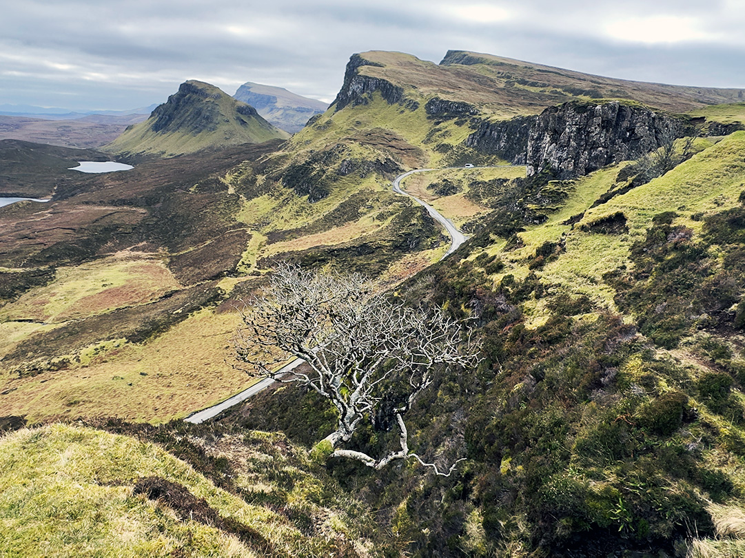
14. The Trotternish Peninsula loop, Isle of Skye
- Distance: 50 miles loop
- Time: 2.5 hours (without stops)
- Best for: seeing the biggest sights on Skye in one drive
- Watch out for: crowds in summer, parking at the famous viewpoints
- Don’t miss: the Old Man of Storr, Kilt Rock, the Quiraing, the Fairy Glen, Rubha Hunish
- Where to eat: the Ferry Inn at Uig (book ahead)
The circular route around the Trotternish Peninsula on the Isle of Skye visits some of the biggest and best sights on the island. From the Fairy Glen to the Quiraing, Kilt Rock and Mealt Falls, and the Old Man of Storr.
The small hamlet of Uig on the Trotternish peninsula is where the ferries depart for the Outer Hebrides. The lovely Ferry Inn is a great place to stay if you want to explore Trotternish from a base in Uig.
To leave the crowds behind, hike out to Rubha Hunish and the Lookout Bothy. The most northerly tip of the Trotternish peninsula and indeed of Skye, Rubha Hunish is a great place to spot wildlife, including whales and orcas from the cliffs that drop down into the sea.
A warning. Thanks to Instagram, the Trotternish Peninsula (including the Fairy Glen and Kilt Rock) has helped make the Isle of Skye Scotland’s most famous island. It has also led to some disappointing headlines of poor parking, overrun locations, and litter and campervan waste being dumped by the side of the road.
Think about visiting Skye in the off-season when the roads are much quieter, and the views just as spectacular.
Read more: the complete guide to the Isle of Skye.
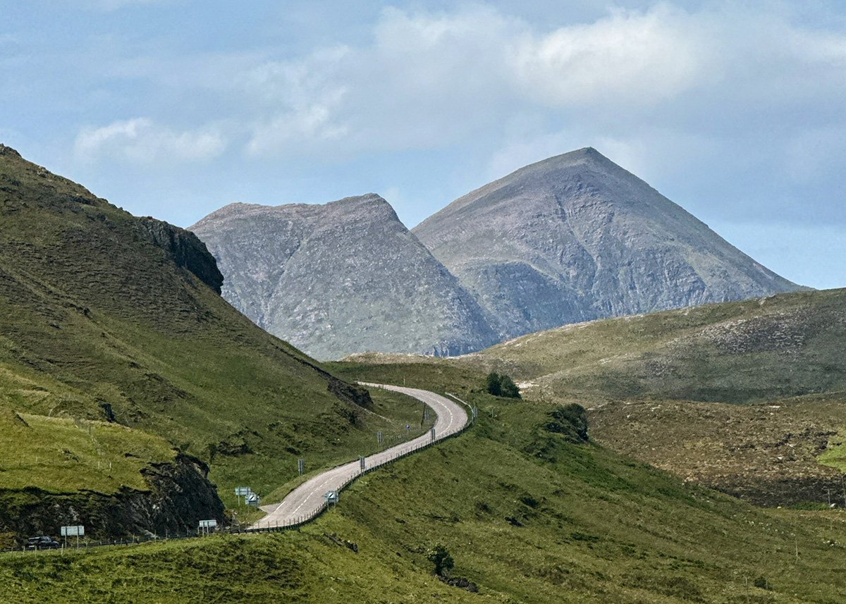
15. The A939, Cock Bridge to Tomintoul
- Distance: 14 miles
- Time: 30 minutes (in good weather)
- Best for: open moorland, the most exposed road in Scotland
- Watch out for: the A939 closes more often than any other road in Scotland
- Don’t miss: the Lecht ski centre, the Corgarff Castle viewpoint
- Where to eat: Bridge of Brown Tearoom (seasonal)
The A939 between Cock Bridge and Tomintoul is famous for being the most snow-affected road in Scotland. It runs over open moorland at over 600 metres for several miles and closes regularly between November and March (sometimes April).
In good weather it’s a brilliant drive. The road climbs out of upper Strathdon, passes the ruined Corgarff Castle, crosses the Lecht ski centre at the highest point, and drops down to Tomintoul on the other side. The combination of altitude, exposure and the way the wind hits this section means the snow can blow over the road within minutes when it starts.
If you’re driving the North East 250 in winter, this is the section to plan around.
More Scotland road trips
If you’ve got the time for a multi-day route rather than individual drives:
- The North Coast 500 — 516 miles, 7-10 days
- The North East 250 — 250 miles, 5-7 days
- The South West Coastal 300 — 300 miles, 5-7 days
- Southern Scotland road trip — 500 miles, 7 days
- 7-day Classic Scotland itinerary — Edinburgh, Loch Lomond, Glencoe, Loch Ness
- How to plan a Scotland road trip
FAQs
What is the most scenic road in Scotland?
Bealach na Bà to Applecross is the most dramatic and most-photographed road in Scotland. Britain’s third-highest public road, with hairpin switchbacks rising to 626 metres in just 6 miles. The drive to Kinloch Hourn (Britain’s longest dead-end road) and the Mam Ratagan pass to Glenelg are close behind for sheer beauty.
What is the most dangerous road in Scotland?
The Drumbeg Loop off the NC500 is genuinely the most challenging public road in Scotland, with blind hairpins and tight passing places. The final descent to Kinloch Hourn is steep and twisting. Bealach na Bà has the reputation but is well-engineered. The A939 over the Cairngorms is the most weather-affected road and closes more often than any other in Scotland.
Which Scottish roads are unsuitable for motorhomes?
Bealach na Bà is officially advised against for motorhomes (signs at the bottom recommend the alternative coast road). The final descent to Kinloch Hourn is too steep and narrow for anything bigger than a small car. The Drumbeg Loop is technically possible but reversing on blind corners is unpleasant in a motorhome. Mam Ratagan is doable in a small motorhome but the climb is steep.
When is the best time of year to drive Scotland's scenic roads?
May, June and September are the best months. Long days, mild weather, the worst of the midges has either not started or is over, and the snow has cleared from the high passes. October is excellent for autumn colour. Winter is dramatic but the high mountain roads (the Snow Road, the A939) close regularly. Avoid mid-July to mid-August unless you want the company.
Are Scotland's mountain roads open in winter?
Some yes, some no. The A82 through Glencoe stays open all year (gritted regularly). Bealach na Bà closes in heavy snow but isn’t gritted. The A939 between Cock Bridge and Tomintoul closes more often than any other road in Scotland. The Snow Road (A93) closes in significant snow. The Three Lochs Forest Drive is closed to cars between November and February. Always check before you set off.
Do you need a 4×4 for Scottish driving roads?
No, almost never. A standard hire car can drive every single road in this guide in good weather. A 4×4 is genuinely useful only in winter on the higher passes (the Snow Road, the A939) or in heavy snow elsewhere. Save the upgrade fee.
Happy driving.
Love, from Scotland x
Leave a Reply