Thinking about climbing Ben Nevis – the UK’s highest mountain – but not sure you’re ready? Then this is the guide for you.
I’m not a mountaineer or extreme adventurer. I’m a regular hillwalker who once thought Ben Nevis was well beyond me.
In this post, I’ll walk you through exactly what climbing Ben Nevis is like, how long it takes, how hard it really is, when to go, where to park and what you need to know before setting off. Let’s climb Ben Nevis.
Climbing Ben Nevis at a glance
- Height: 1,345 metres (4,413 ft) – highest point in the UK
- Best route up Ben Nevis for beginners: Mountain Path (Pony Track)
- Distance: 17.7 km (11 miles) round trip
- Total ascent: 1,345 metres
- Time: 7–9 hours for most walkers
- Difficulty: Moderate–Strenuous (fit beginners can do it)
- Start point: Glen Nevis Visitor Centre
- Best months to climb Ben Nevis: May–September
- OS Map: Landranger 41 / Explorer 392
The route is suitable for fit beginners, but it is not an easy walk. Weather can change rapidly, navigation is difficult in fog, and proper clothing and preparation are essential.
The best time to climb Ben Nevis is late spring to early autumn, with May and September offering the best balance of conditions and crowds. Winter ascents require specialist skills and equipment.
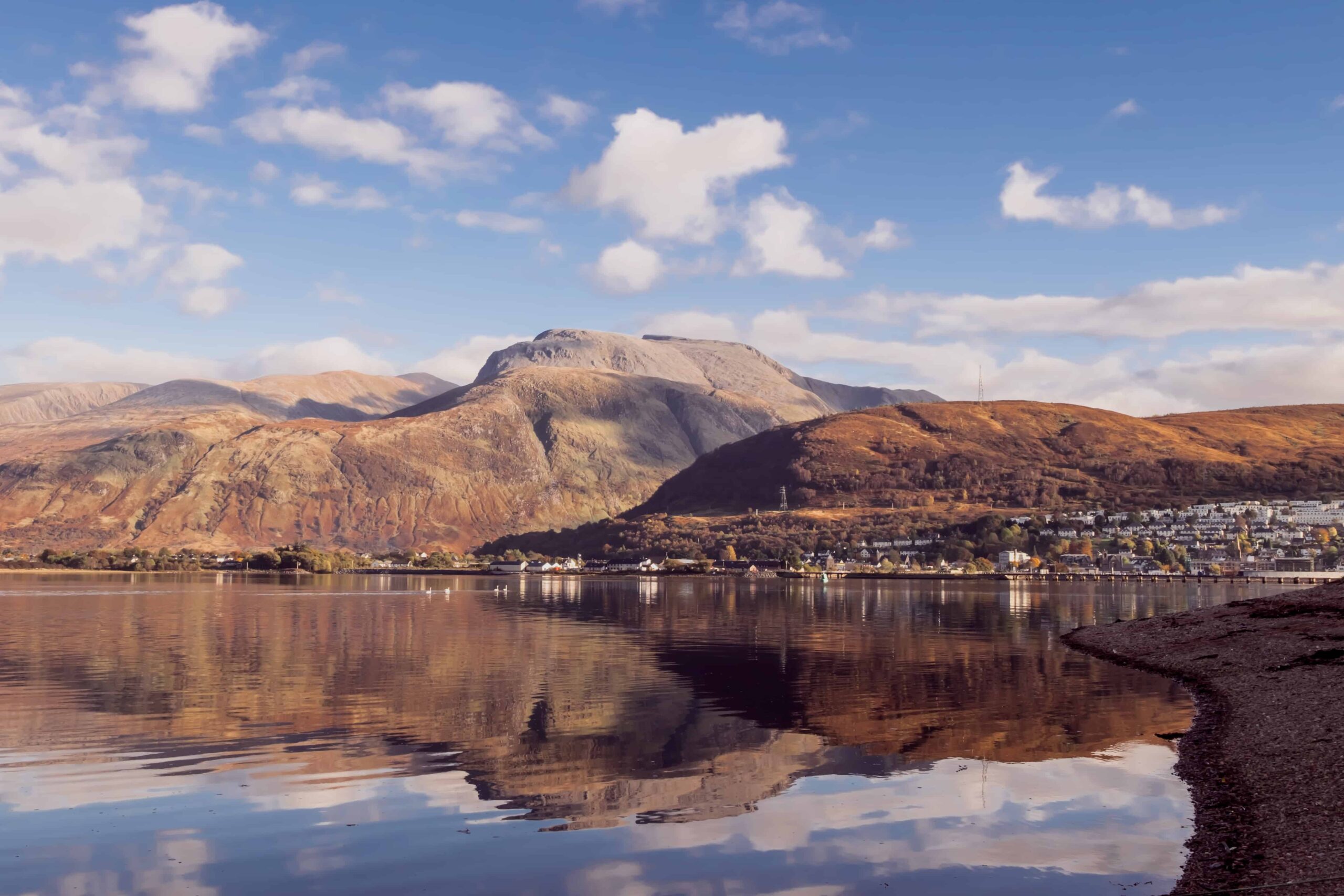
Where Is Ben Nevis?
Ben Nevis is located in Lochaber in the Scottish Highlands, around 1.5 miles from Fort William. It forms part of the Nevis Range in the Grampian Mountains and at 1,345 metres is the highest mountain in the UK – higher than anything in England or Wales.
The nearest town is Fort William, which has good rail and road links from Glasgow and Inverness. Most people base themselves here or in Glen Nevis itself the night before.
How to get to Ben Nevis
By car: Drive into Glen Nevis from Fort William, it’s well signposted. The Glen Nevis Visitor Centre is your destination.
By bus: A seasonal bus service runs between Fort William town centre and Glen Nevis from May to September (Fort William Glen Nevis Route No: 42)
By taxi: A taxi from Fort William costs approximately £10 each way and takes about 10 minutes.
By train: Fort William has a direct rail link from Glasgow Queen Street (around 3.5 hours).
Parking at Ben Nevis
There are three main parking options:
- Glen Nevis Visitor Centre – the most popular and most convenient. Around 80 spaces. Charge applies (currently around £8/day, verify on arrival as prices may have changed). There are toilets and an information centre on site. The car park is first come first served, so consider taking the bus from Fort William.
- Ben Nevis Inn / Achintee – the Inn’s car park is strictly for the Inn’s customers. There is a smaller free car park near to the Inn, it is slightly further from the official Mountain Path start but the location is perfect to head to the pub at the end of your day.
- Braveheart Car Park – located at the entrance to the glen, further away from the start of the walk. £3 for all day.
The Glen Nevis Youth Hostel also has a car park with limited spaces if you’re staying there.
Tip: Arrive well before 8am on summer weekends. The Visitor Centre car park fills up quickly, especially during school holidays and organised events.
The Visitor Centre and toilets are open from approximately 8am–4pm in spring through late autumn. These are the last toilets you will see until you return, there are no facilities on the mountain.
The Ben Nevis Mountain Path: step by step
The Mountain Path (also called the Pony Track, Tourist Route, or Ben Path) is the standard route for first-time visitors and beginners. It’s the safest, most straightforward, and busiest way to the summit.
Don’t be misled by the “Tourist Route” name, this is still a serious, strenuous walk.
Stage 1: Visitor Centre to the Halfway Lochan (0–5km, 1.5–2 hours)
From the Visitor Centre, cross the bridge over the River Nevis, turn right along the riverbank, then follow the signs. The first section climbs steeply, this initial push, sometimes called “Heart Attack Hill” by locals, is actually one of the steepest sections of the whole route and will certainly warm you up for the day ahead.
The path passes through woodland and open hillside before arriving at Lochan Meall an t-Suidhe (the Halfway Lochan) at around 570 metres. This is a natural rest stop. There’s a junction here, turn right, heading south towards the Red Burn. Don’t take the path heading straight ahead.
Stage 2: The Red Burn and the Zigzags (5–7.5km, 1–1.5 hours)
After the lochan, the path crosses the Red Burn, a useful water source if you have a filtration system, though don’t drink directly from it unfiltered. Beyond the burn begins the infamous upper zigzags.
This is where Ben Nevis starts to hurt. The zigzags are well-maintained but relentless, each one progressively shorter as the terrain gets rougher. The path underfoot changes from good track to shale, loose rock, and boulders. Go slowly, keep a steady pace, and don’t try to cut the corners of the zigzags (it causes erosion and doesn’t save much time).
Stage 3: The Summit Plateau
Above the zigzags, the gradient eases slightly as you reach the edge of the summit plateau. The path continues past Five Finger Gully, then Tower Gully and then finally Gardyloo Gully. These are all serious hazards in poor visibility, where walkers have fallen to their deaths.
A line of cairns mark the direction just before the summit. However, in very low cloud you will not be able to see the next cairn ahead of you, and you’ll need to make decision whether you are able to navigate safely to the top, which is 150 metres away at this point. In heavy snow, the cairns can even be buried.
If you do get stuck with no visability, this is where your compass comes in. To get back down from the summit cairn, walk 150 metres on a bearing of 231°, then 282° to reach the top of the Mountain Path zigzags, as shown on this map. Learn how to take a bearing and practise mountain navigation before you head up the hill. This video show you how to take a bearing.
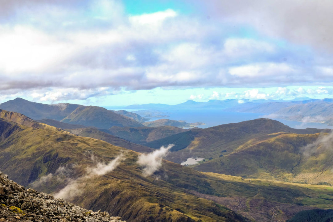
The summit (1,345m) contains the ruins of the old observatory, a trig point, an emergency shelter, and on a clear day, views across to Northern Ireland. On most days, however, you’ll be in thick cloud.
How long does it take to climb Ben Nevis?
Most walkers: 7–9 hours round trip
- Visitor Centre → Halfway Lochan: 1.5–2 hours
- Halfway Lochan → Top of zigzags: 1–1.5 hours
- Top of zigzags → Summit: 30–45 mins
- Total ascent: ~4–4.5 hours
- Descent (summit → Visitor Centre): 2.5–3.5 hours
- Full round trip: 7–9 hours
Faster, fitter walkers complete it in 5–6 hours. Allow 9–10 hours if you’re less experienced, taking it steady, or the weather is difficult. Starting by 9am in summer gives you plenty of daylight buffer.
Is climbing Ben Nevis hard?
Honestly? Yes. But most reasonably fit people with proper preparation can do it.
Ben Nevis by the Pony Track is not a technical climb, you don’t need ropes, specialist equipment (in summer), or mountaineering experience. But it is long, steep, and relentless. The ascent is 1,345 metres from near sea level, and the descent is harder on your knees than the climb up.
You are ready to attempt Ben Nevis if you:
- Regularly walk 10+ miles comfortably
- Have done some smaller hill walks (a few beginner Munros is ideal)
- Are comfortable with uneven, rocky terrain
- Have the right kit (see below)
You should build more experience first if you:
- Rarely walk more than a few miles at a time
- Haven’t done any significant uphill walking
- Are relying on fair weather to make it achievable
Are there toilets on Ben Nevis?
No.
Is there a cable car up Ben Nevis?
No. The Nevis Range Gondola goes up Aonach Mòr, not Ben Nevis.
Is Ben Nevis dangerous?
In good weather with the right preparation, the risk is manageable. But Ben Nevis has a serious safety record, and complacency causes accidents.
The main hazards are:
- Rapid weather changes – it can be warm and sunny at the bottom and freezing with zero visibility at the summit within the same day. The mountain averages only around 14 clear summit days per year.
- Navigation difficulty in fog – the summit plateau is confusing. People have walked off the cliff edges of Tower Gully and Gardyloo Gully in poor visibility. If you can’t see clearly, don’t go to the summit.
- Descent fatigue – most accidents happen on the way down. You’re tired, your knees are taking a beating, and it’s easy to make poor decisions. Leave plenty of time and energy.
- Underestimating the conditions – snow can sit on the upper path from September to July. If there’s snow, treat it as a winter route, you’ll need an ice axe, crampons, and the skills to use them.
Carry a map and compass and know how to use them. Never rely solely on your phone’s GPS.
What to pack for Ben Nevis
Clothing
- Waterproof jacket (essential, even in sunshine)
- Waterproof trousers
- Warm mid layer (fleece or down jacket)
- Hat and gloves (even in summer, it’s often sub-zero at the summit)
- Moisture-wicking base layer
- Sturdy ankle-supporting walking boots, not trainers, not casual shoes
- Good walking socks (wool or synthetic, no cotton)
Food and Water
- Minimum 2 litres of water
- High-energy snacks: flapjacks, nuts, energy bars, sandwiches
- A hot drink in a flask, very welcome at the summit
- More food than you think you need
Navigation
- Printed OS map (Landranger 41 or Explorer 392) – laminate it or use a map case
- Compass and an understanding of how to use it. If there is a chance of bad weather, don’t risk the climb or use a Ben Nevis guide.
Safety
- Phone with OS Maps downloaded offline
- Portable battery pack (cold kills phone batteries fast)
- Head torch (even on summer days, descents can run late)
- Basic first aid kit
- Emergency bivvy bag or foil survival blanket
- Sunscreen and sunglasses (glare off snow and bright days at altitude)
Tell someone your plan. Before you go, let someone know your route, expected return time, and what to do if they don’t hear from you.
Ben Nevis Weather: what to expect
Ben Nevis has its own microclimate. Even the dedicated Ben Nevis Weather Forecast frequently shows conditions dramatically different from Fort William in the glen below.
Key numbers:
- Summit temperature can be 15–20°C colder than down in the glen
- Average wind speed at the summit: around 30 mph
- Ben Nevis averages around 14 clear summit days per year
- Snow can lie on the upper path from September through to July or even August
Best forecasting resources:
- Ben Nevis Weather (dedicated forecast)
- MWIS — West Highland Forecast
- Met Office Mountain Forecast
- Mountain Forecast
Check all of them, not just one. Avoid days with forecast winds above 20 mph near the summit.
When is the best time to climb Ben Nevis?
Best months: May and September
- May: Good daylight hours, paths less busy, snow retreating from the lower sections, fewer midges.
- June–August: Maximum daylight, warmest temperatures, but by far the busiest. Weekend car parks fill by 8am.
- September: Quieter than summer, still manageable conditions, beautiful autumn light.
- October–April: Treat as a winter mountaineering route. Snow, ice, and reduced visibility require crampons, an ice axe, and proper mountain skills. Not suitable without experience.
Which route should I take?
The Mountain Path (recommended for beginners)
The route described throughout this guide. Well-signposted, well-maintained, and well-populated, other walkers are rarely far away. No scrambling required. Still demanding, but achievable for fit beginners.
Start: Glen Nevis Visitor Centre
Distance: 17.7km (11 miles) round trip
Ascent: 1,345 metres
The CMD Arête (experienced hillwalkers only)
The Càrn Mòr Dearg Arête is a spectacular horseshoe route via a neighbouring peak. It involves Grade 1 scrambling on a narrow, exposed ridgeline, thrilling in summer, very difficult in any other season. Do not attempt without experience on ridge terrain and a good head for heights.
Accommodation Near Ben Nevis
- Glen Nevis Youth Hostel – the closest option to the start of the climb, less than a mile away
- Ben Nevis Inn – right at the foot of the Mountain Path, with a well-earned post-hike pint
- Fort William town centre – wide range of hotels, B&Bs and guesthouses, 10–15 mins from the start
Booking accommodation the night before and starting early is strongly recommended, particularly in summer.
Hostels & camping
- A cute glamping pod in Fort William
- Camping and glamping pods at the Glen Nevis Caravan & Camping Park
- Looking for a log cabin? Try the Dontra Chalet
- Stay at the Chase the Wild Goose Hostel
Hotels near Fort William
Frequently Asked Questions
How long does it take to climb Ben Nevis?
Most walkers take 7–9 hours for the full round trip via the Mountain Path. Ascent alone takes around 4 hours for a typical fit walker. Allow more time if you’re less experienced or the weather is slow-going.
Is Ben Nevis suitable for beginners?
Yes, with the right preparation. You don’t need mountaineering experience, but you should be comfortable walking 10+ miles and have done some uphill walking beforehand. The route is not technically difficult, but it is long and strenuous.
Do I need walking boots to climb Ben Nevis?
Yes. Trainers are not suitable. The upper path is rocky, uneven and often wet, icy or covered in snow. Ankle-supporting waterproof walking boots are essential. If there is snow, crampons are required.
Is there parking at Ben Nevis?
Yes, at the Glen Nevis Visitor Centre (around 80 spaces, charge applies), near the Ben Nevis Inn at Achintee and the Braveheart car park at the start of the glen. Arrive early in summer — the Visitor Centre car park fills quickly on weekends.
Are there toilets on Ben Nevis?
Only at the Glen Nevis Visitor Centre at the start. There are no facilities on the mountain itself. Use the toilets before you begin.
Is there a cable car up Ben Nevis?
No. The Nevis Range Gondola goes up Aonach Mòr — a neighbouring mountain — not Ben Nevis. There is no mechanical means of ascent on Ben Nevis.
When is the best time of year to climb Ben Nevis?
May and September offer the best balance of conditions, daylight, and crowds. June–August is the busiest period. October through April requires winter mountaineering skills and equipment.
How hard is Ben Nevis compared to other Scottish mountains?
Ben Nevis is more demanding than most beginner Munros due to its height and ascent distance. A good comparison benchmark — if you can climb Ben Lomond comfortably you have a solid foundation for attempting Ben Nevis.
What happens if the weather turns bad on the mountain?
Turn back — this is always the right decision. If you’re caught in fog near the summit and can’t see the path, use your compass. From the summit cairn, walk 150 metres on a bearing of 231°, then 282° to reach the top of the Mountain Path zigzags.
Can children climb Ben Nevis?
Older children (roughly 10+) with good stamina and walking experience can complete Ben Nevis with the right preparation. It is a very long day and the terrain is rough. Younger children are generally not recommended on this route.
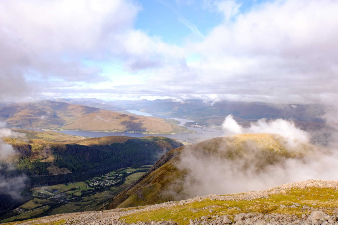
So how did I find climbing Ben Nevis?
I struggled. I doubted myself on those zigzags. I hit the fog around 1,200 metres and couldn’t see more than 20 metres in any direction. And then I reached the top, ate a slightly squashed sandwich, took a photo in the freezing wind, and started back down.
If you’re reasonably fit, properly prepared, and respect the mountain, you can do this. Plan carefully, choose the right day, and don’t underestimate the descent.
Love from Scotland x