
Seabird colonies, fishing villages, coastal walks, island abbeys and crab sandwiches eaten on a harbour wall, welcome to the Firth of Forth.
A tidal estuary stretching 50 miles from Stirling to the open North Sea, the Firth of Forth separates Fife from Edinburgh and East Lothian and has been central to Scottish trade, industry, fishing and warfare for centuries.
Most visitors see it briefly, through a car or train window crossing the Queensferry Crossing. This guide is for those who want to do more than just cross it.
From the bridges to the open sea, the Fife coast to the north, the Lothian coast to the south, and the islands in betwee, there ate medieval abbeys to visit, world-class birdwatching, working fishing harbours, and some of the best coastal walking in Scotland.
Let’s explore the Firth of Forth.
How to use this guide to the Firth of Forth
This guide covers the Firth of Forth in three sections:
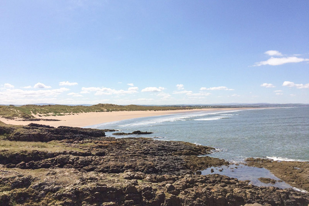
- The north shore — the Fife coast from Culross in the west through Aberdour, the Wemyss villages, Kirkcaldy, and out to the East Neuk and Crail.
- The south shore — from Bo’ness and Grangemouth in the west, through South Queensferry and along the East Lothian coast to Dunbar.
- The Firth of Forth islands — the Isle of May, Inchcolm, Bass Rock, Fidra, Inchkeith and the smaller fortified islands of the Firth.
Did you know? The word ‘Firth’ comes from the Old Norse word fjörðr which is similar to the Scandinavian word fjord. It means a large coastal inlet or estuary.
The north shore of the Firth of Forth
Stretching from Culross to Crail, here is how to explore the north shore of the Firth of Forth.
Culross
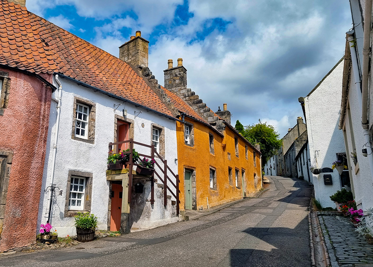
Culross (pronounced Coo-russ) is one of the best-preserved Scottish burghs of the sixteenth and seventeenth centuries. Its tight streets of cottages with their orange pantile roofs have been carefully conserved by the National Trust for Scotland.
The town prospered because of the Forth, coal was mined here, salt panned from seawater, and both exported from the small harbour below the village. Culross is now more famous for its staring role in the TV series Outlander which was filmed in The Cross, the village’s main square, and in the Palace’s gardens.
- What to see: Take a stroll along the cobbled streets to Culross Palace (a prosperous merchant’s house rather than a royal residence, despite the name), the Town House, and the Culross Abbey ruins on the hill above. Theres is a market most sundays (weather permitting) on the village green.
- Eat and drink: The Red Lion is a community run pub which serves food. Grab coffee and cakes from The Mercat on The Cross. On the weekend, The Stickman serves up inventive tacos from a stall next to the east carpark.
- Stay: The Dundonald is a stylish B&B on one of Culross’s prettiest streets.
- Getting there: About 12 miles west of the Forth Bridge on the A985. Easiest by car, free parking in two car parks at the ends of the village. From Dunfermline, bus 8A runs to Culross.
Read more – plan your visit to Culross
The Charlestown to Limekilns coastal walk
Distance: 2.5 miles one way | Grade: Easy | Terrain: Coastal path and foreshore
A short linear walk connecting two of the Fife shore’s most interesting old settlements. Charlestown was laid out in the 1750s by the Earl of Elgin to house workers in his limestone industry, the rows of workers’ cottages and the remains of 14 lime kilns are still there.
The coastal path east runs along the foreshore to Limekilns, a small harbour village with views across to the Forth Bridges and South Queensferry. Robert Louis Stevenson set scenes from Kidnapped here.
Stop in Limekilns for a coffee or lunch, The Bruce Arms is a personal favourite.
North Queensferry
Cross the Forth Bridge by train and get off at the first stop. North Queensferry is a small village on the Fife shore directly beneath the bridge, and the view looking up from the pier is fantastic.
The foreshore walk east towards Carlingnose Point is short, easy and has views back across the full width of the Firth that are hard to beat.
If you are looking for lunch or dinner in North Queensferry, The Wee Restaurant is a favourite spot.
Aberdour
Aberdour is 30 minutes from Edinburgh by train. Aberdour’s twelfth-century Castle is one of the oldest standing castles in Scotland, well-maintained by Historic Environment Scotland. Silver Sands Beach below the town is a blue flag site, sheltered and unusually sandy for the Firth.
The coastal path west from Aberdour towards Dalgety Bay passes above rocky foreshore with good views across the Firth to Edinburgh and the Lothian hills.
The Aberdour to Burntisland coastal walk
Distance: 2.5 miles one way | Grade: Easy | Terrain: Coastal path.
The path between Aberdour and Burntisland runs above the water with views across the Firth. Burntisland is an old port town with a medieval church that has a reasonable claim to being where the King James Bible was first proposed, at an assembly held here in 1601.
Aberdour and Burntisland’s train stations are on the Edinburgh–Dundee line, making the one-way walk straightforward.
Dysart and the West Wemyss coastal path
The coast between Dysart and West Wemyss is one of my favourite walks on the Fife shore.
Distance: 4 miles one way | Grade: Moderate | Terrain: Coastal path, uneven in places
Dysart has a fabulous old harbour, and the coastal path passes the ruins of Ravenscraig Castle before reaching West Wemyss, a village of seventeenth-century crow-stepped cottages almost directly above the water.
The Wemyss Caves along the shore contain some of the finest Pictish rock carvings in Scotland. The caves are fragile and access is managed; find out more about the Wemyss Caves.
Kirkcaldy
Kirkcaldy, otherwise known as the Lang Toun, is the largest town on the Fife coast and the birthplace of Adam Smith, whose Wealth of Nations helped shape the modern economic world. The town museum has a decent collection of Scottish art and local history. Kirkcaldy is primarily useful as a transport hub, but the old harbour area and the seafront promenade are worth a walk if you’re passing through.
Lower Largo
Lower Largo is a small village on the Fife coast with one significant claim to fame – it was the birthplace of Alexander Selkirk, the Scottish sailor whose real-life castaway experience on a Pacific island inspired Daniel Defoe’s Robinson Crusoe. A statue of Selkirk stands on the cottage where he was born on the main street.
The village itself is pretty, a row of old cottages along a tidal burn running to a sandy beach, with views across the Forth. The beaches at Lower Largo and neighbouring Lundin Links is wide and good for walking at low tide.
- Eat and drink: The Crusoe Hotel bar is a great place for dinner and drink with a view. The Railway Inn is a proper local pub in the village, unpretentious and good for a pint & a pie.
- Stay: The Crusoe Hotel is a characterful harbourside hotel that leans into its Selkirk connections without overdoing it, with rooms looking out across the beach and the Forth. Book ahead in summer.
- Don’t miss: a visit to the Largo Castaway Sauna and a dip in the sea.
The Fife Coastal Path: East Neuk highlight section
The Fife Coastal Path runs 117 miles in total from Kincardine to Newport.
The East Neuk section between Elie and Crail is the most popular and most rewarding, and can be walked independently of the rest of the route.
Elie to Crail via the East Neuk towns
Distance: 13 miles | Grade: Moderate | Best done in: 1–2 days with an overnight in Pittenweem or Anstruther
The path moves between harbours, clifftops, beaches and links land, passing through all the main East Neuk towns. It can be walked in one long day by fit walkers, but splitting it over two days gives proper time in Pittenweem and Anstruther. This is one of the best stretches of coastal walking in Scotland.
Elie and Earlsferry
Elie and its neighbour Earlsferry together form one of my favourite places on the Fife coast. Elie Beach is wide and sandy, the harbour is pretty, and the walk east along the headland to the Elie Chain Walk is one of the most unusual short excursions in Fife.
The Ship Inn is deservedly well known, it sits right on the beach, the beer garden faces the sea, and in summer beach cricket is played on the sand in front of it.
The Elie Seaside Sauna is a wood-fired horsebox sauna sitting above the shoreline, with the Forth on your doorstep and a cold dip in the sea to follow. It’s become one of the more popular wellness experiences on the Fife coast.
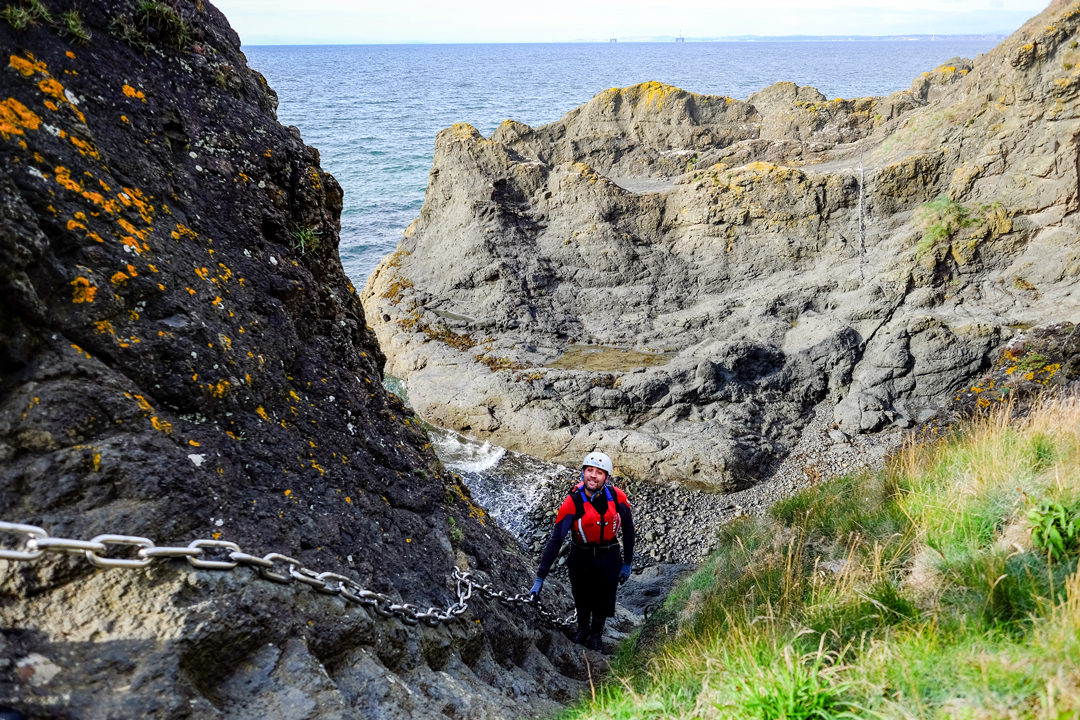
The Elie Chain Walk
Grade: Challenging (scrambling, tidal dependent) | Not suitable for: Young children, or anyone without a reasonable head for heights
The Chain Walk is not a conventional coastal path. It traverses the rocky foreshore around Kincraig Point using iron chains bolted into the cliff face at difficult sections, requiring moderate scrambling and some exposure. It is tidal-dependent and should not be attempted on a rising tide or in wet conditions. Check tide tables before going and wear boots with grip. The circuit from Elie Harbour is about 2 miles and takes around 90 minutes.
Read more – how to climb the Elie Chain Walk.
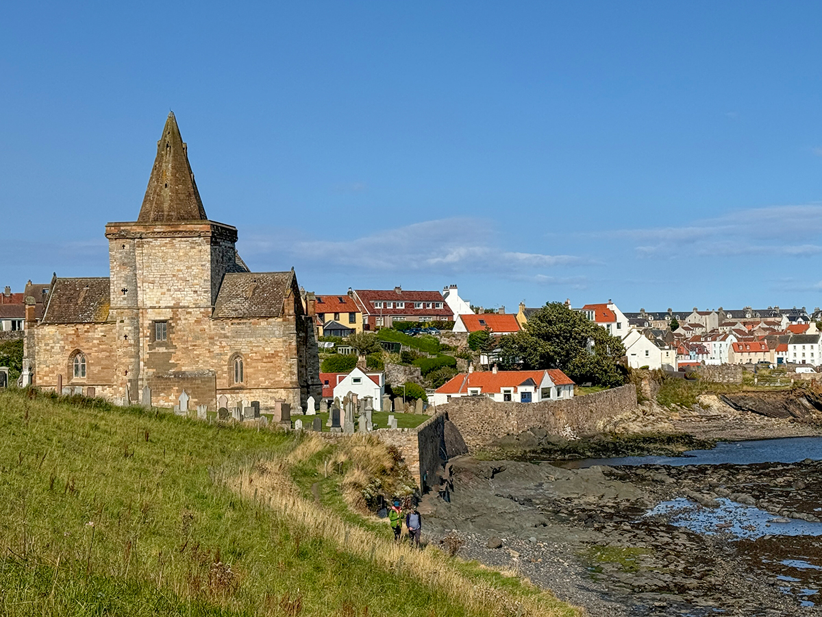
St Monans
St Monans is the smallest and probably the quirkiest of all the East Neuk villages.
The village is named after Saint Monan – who was martyred on the Isle of May out in the Forth and who set up a chapel in the East Neuk. There is a shrine erected to St Monan in the striking church on the waterfront.
The fourteenth-century church sits almost on the waterline at the edge of town, close enough to the sea that at high tide the water reaches the graveyard wall.
St Monans has an unusual wiggly harbour – the star of many an instagram shot – you can find it by climbing up the harbour wall. There is also a welly boot garden on St Monans slipway, started by local teacher, Win Brown, the welly boot garden now contains lots colourful boots, winning St Monans a few awards.
Walking the Fife Coastal Path towards Pittenweem you will pass the St Monans windmill, a relic from the 1770s of the salt panning industry which once dotted the coast.
For lunch try the fantastic seafood at East Pier Smokehouse or sandwiches, coffee and cake at the Diving Gannet.
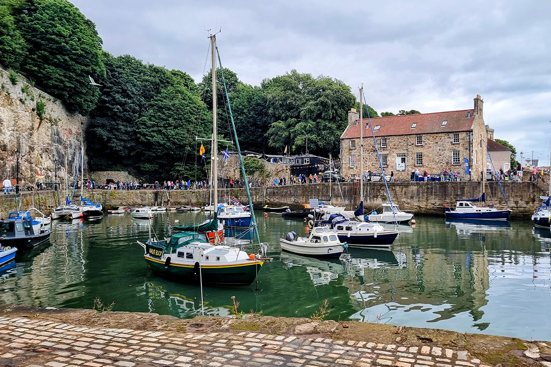
Pittenweem
Pittenweem is a busy fishing port, with the fish market operating most mornings in season, arrive early if you want to see it at work – there might be lobsters, herring or langoustines on offer.
The name ‘Pittenweem’ means place of the caves – Pett means place, enweem means caves. Pittenweem is home to the tiny St Fillan’s Cave – home to the Irish missionary in the 7th century.
In August, the fabulous Pittenweem Arts Festival takes the small town, with over 100 artists displaying their works in galleries and in their own homes, sheds and garages.
If you are visiting Pittenweem you must visit the Pittenweem Chocolate Company and coffee shop, heaven for chocolate fans!
The West End Bar at the top of the town is a friendly pub which serves up great food and occasionally has live music.
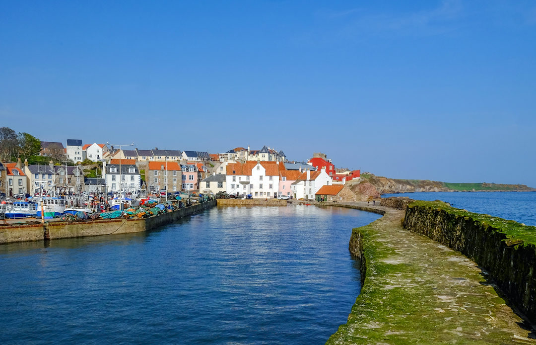
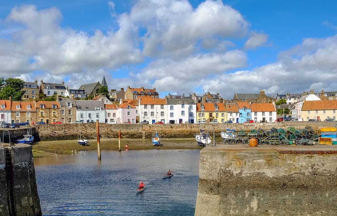
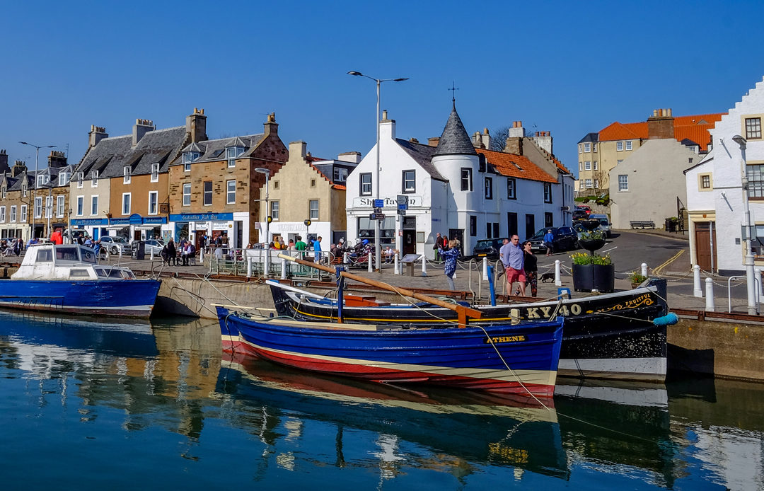
Anstruther
Anstruther (pronounced Anster locally) is the largest of the East Neuk towns.
The Scotland’s Fishery Museum is genuinely excellent, with a collection covering the full history of Scottish fishing from early subsistence to the herring boom and its collapse. There are 18 boats on display, one of which, Reaper, was used in the hit TV series Outlander.
The fish and chips at the Anstruther Fish Bar have a reputation extending well beyond Fife, and mostly live up to it. The Wee Chippy is a popular alternative.
Anstruther is the departure point for trips to the Isle of May – a great place to see puffins in Scotland in Summer.
From Anstruther you can walk the Fife Coastal Path to Crail, passing through Cellerdyke with its tiny 16th century harbour, which is also known as Skinfast Haven once home to more than 50 herring boats.
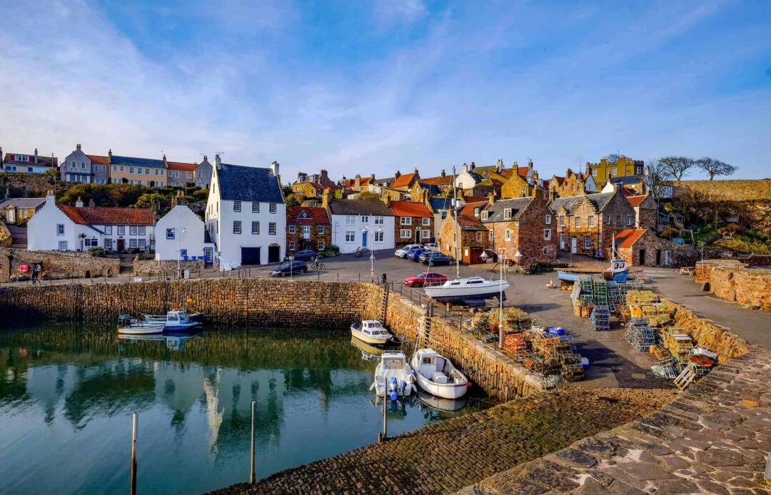
Crail
Crail is the most easterly and most photographed of the East Neuk towns. The harbour – reached down a steep lane from the Market Square – is small and lovely, with lobster pots, painted boats and old stone buildings.
From the high street, pop into the Crail Pottery and then follow the winding coastal path down to the pretty harbour.
Crail has something of a foodie reputation, with the Crail Food Festival taking place every June. Outside of the festival, a seafood shack ‘The Lobster Hut’ on the harbour side serves up crab rolls and plates of lobster. Bring the champagne, the salads, and grab a bench for a complete feast.
After lunch, the walk east along the clifftops towards Fife Ness is one of my favourite short coastal walks in the East Neuk.
Crail to Fife Ness coastal walk
Distance: 3 miles one way | Grade: Easy | Terrain: Coastal path, clifftop
The path from Crail Harbour east to Fife Ness follows the clifftop above rocky bays with continuous views across to the Isle of May and, on clear days, to Bass Rock.
At Fife Ness, the easternmost point of Fife, you’re looking out towards the open North Sea. A good spot for seabirds year-round, and for watching migrating birds pass through in spring and autumn.
The south shore of the River Forth
Grangemouth
Your starting point for your trip along the south shore of the Firth of Forth is Grangemouth – a place that does notappear in many travel itineraries.
The Grangemouth petrochemical complex is Scotland’s largest industrial site, a landscape of towers, pipes and flare stacks that is genuinely striking when seen across the Forth at dusk, whatever your feelings about what it represents.
Worth a look from the opposite shore!
Bo’ness (Borrowstounness)
Bo’ness was once one of the most significant ports in Scotland, the third largest at its peak, and its industrial past is visible in the architecture, the dockside, and the heritage attractions based here.
The Bo’ness and Kinneil Railway is a heritage steam railway operated by volunteers along the foreshore, with a good collection of locomotives and rolling stock and a range of special events throughout the year.
The Hippodrome on the High Street is Scotland’s oldest purpose-built cinema (1912), beautifully restored and still showing films.
Kinneil House and Estate west of the town has the ruins of Kinneil House, a Roman Antonine Wall fortlet, a country park with good walking, and the cottage where James Watt worked while developing the steam engine.
Getting there: On the A904, about 30 minutes from Edinburgh or Stirling by car. Served by the Falkirk High rail line.
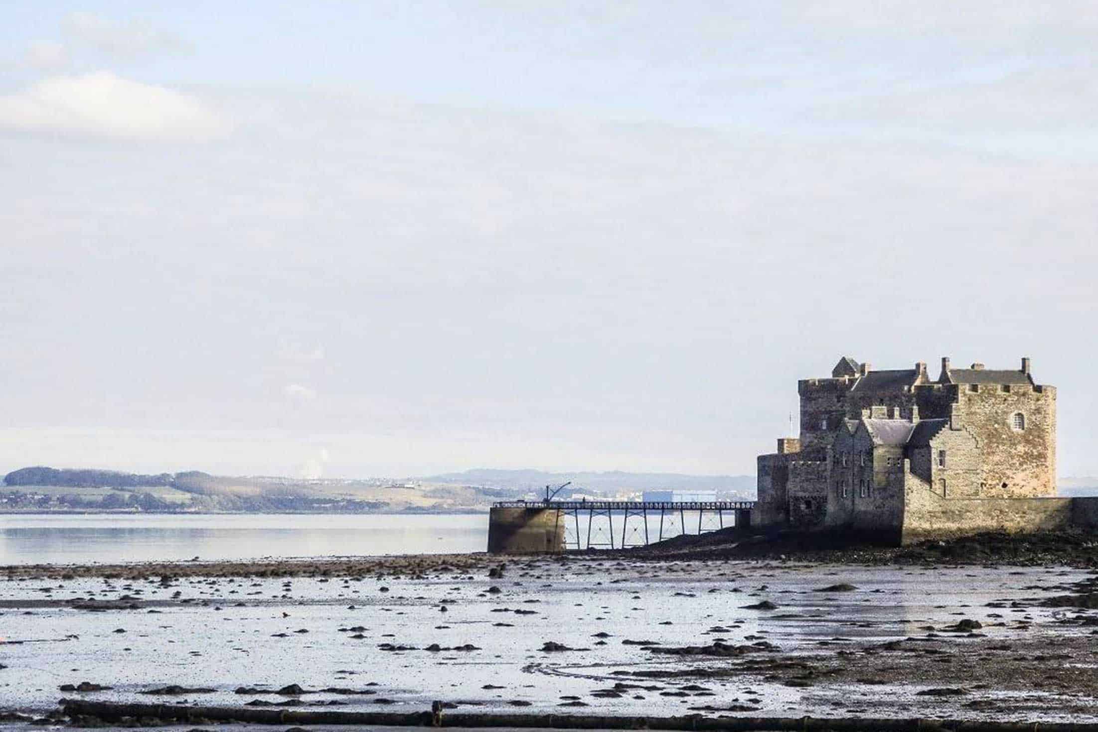
Blackness Castle
Blackness Castle has been called the Ship that Never Sailed for centuries, and standing on the foreshore looking at it, you can see exactly why, the fifteenth-century structure follows its headland so closely that the resemblance to a vessel run aground is genuinely convincing.
The history is suitably dark, the castle was once a state prison, Covenanter holding cell, and an ammunition depot.
Historic Environment Scotland manages the site and Outlander visitors will know Blackness Castle it as Wentworth Prison.
The Lobster Pot in the village is a good stop for lunch before or after a visit to Blackness Castle.
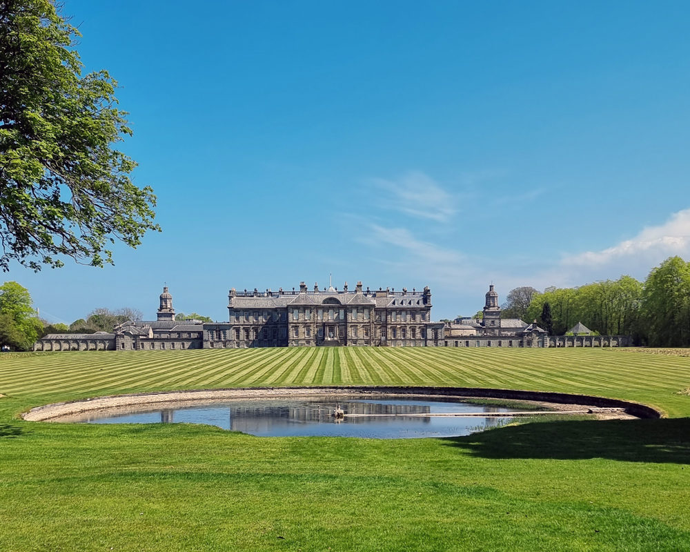
The Hopetoun Estate
Hopetoun House is one of those Scottish country houses that genuinely lives up to its reputation. A grand stately home near Edinburgh, Hopetoun House has an untouched Georgian interior and is one of the finest examples of 18th century architecture in the UK.
Surrounded by 6,500 acres of parkland, the house sits on the River Forth and has incredible views to the Forth Bridges and Blackness Castle.
Designed by William Bruce and expanded by William Adam, it sits in sweeping parkland on the south shore of the Forth a few miles from South Queensferry.
The State Apartments are worth seeing, the rooftop views across the Forth are excellent, and the walk along the shoreline through the deer park is a very good reason to stay longer than you planned.
- To explore the estate, follow the Spring Garden Trail and Sea Walk Trail. Download the Hopetoun House Estate map before your visit.
- BOOK – Tickets to the grounds are £5.50 per person. Tickets to the house and grounds can be booked together. It is worth booking in advance. The house and grounds are open Friday, Saturday, Sunday & Monday.
Plan your visit to Hopetoun House
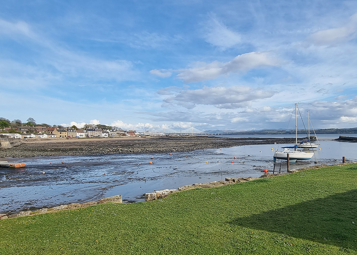
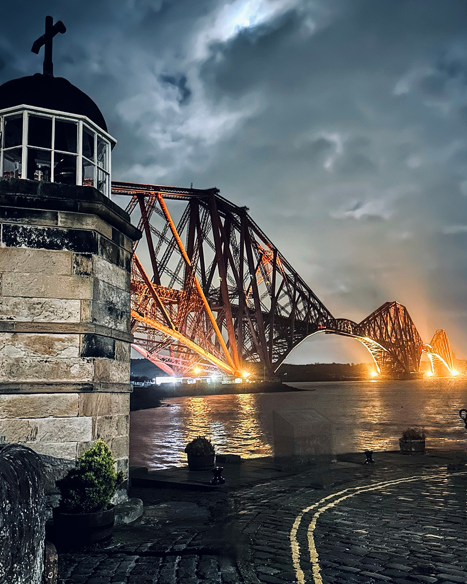
South Queensferry and the Forth Bridges
South Queensferry is probbaly the most famous village on the River Forth. Sitting directly beneath the three Forth bridges and is better for it than almost any other town in Scotland.
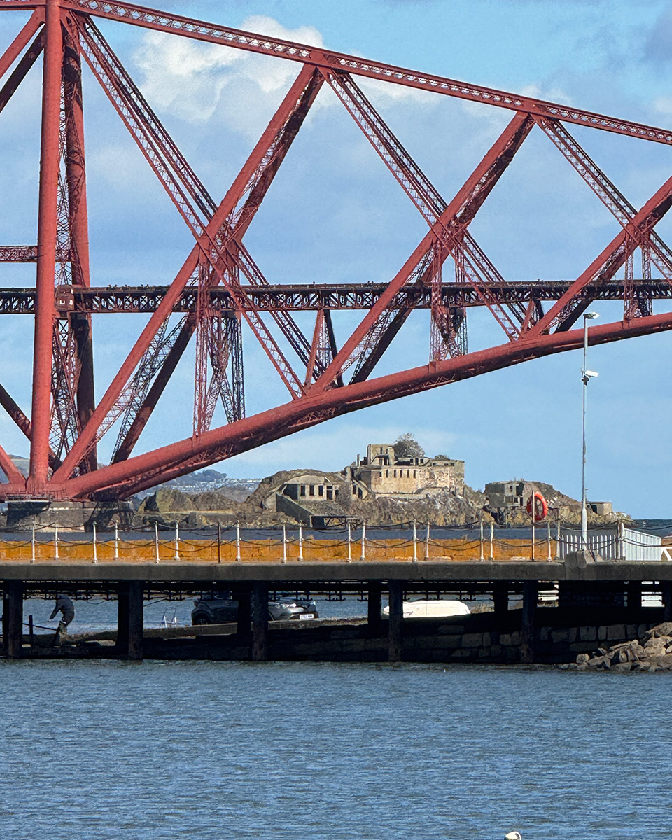
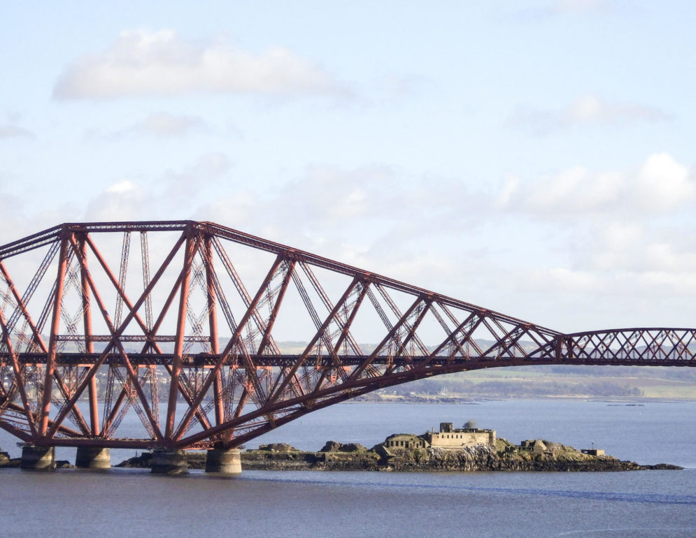
The Forth Bridge is an 1890 Victorian cantilever rail bridge and an UNESCO World Heritage Site. The bridge is best seen from South Queensferry, ideally at high tide when the water is close and the scale of it is most apparent. Nothing prepares you fully for how large it is.
The town itself has a pretty high street, with shops and cafes, along with a small museum covering the history of the bridges and the crossing.
Dalmeny Estate immediately to the west, a coastal estate with excellent woodland and shore walking, with a great view of the three Forth bridges, the Rail Bridge, the Road Bridge, and the Queensferry Crossing… which will forever be known to those from Edinburgh as the New Bridge.
Hawes Pier is where the boat to Inchcolm Island departs.
Edinburgh’s Forth shore: Cramond, Leith and Portobello
Edinburgh sits on the south shore of the Forth, and while most visitors head straight into the Old Town, the city’s relationship with the estuary is worth exploring. Three areas in are particularly worth a visit.
Cramond
Cramond sits where the River Almond meets the Forth and is a village of whitewashed cottages, an old harbour, and a foreshore walk that feels a long way from the city even though it’s only twenty minutes by bus from the centre.
The Romans had a fort here; the foundations are still visible near the church. At low tide, a concrete causeway emerges across the mudflats to Cramond Island, a tidal island used for military purposes in both World Wars. Check tide tables before crossing, and do not linger. People are caught out by the tide here every year.
The foreshore walk east from Cramond towards Dalmeny Estate and South Queensferry is one of the best coastal walks in Edinburgh, about 4 miles one way, flat and well-maintained, running through mature woodland above the shore with views across to the Fife coast. Return by bus from South Queensferry or arrange a pickup.
Leith
Leith has been Edinburgh’s port for centuries and is now one of the most interesting parts of the city. The Shore, a row of restaurants and bars along the Water of Leith where it reaches the docks, is the best concentration of good eating and drinking in Edinburgh outside the city centre.
The Royal Yacht Britannia is berthed at Ocean Terminal and is genuinely worth visiting: the preserved interiors give an unexpectedly intimate picture of royal life at sea in the twentieth century, and the audio guide is one of the better ones in Scotland.
Portobello
Portobello is Edinburgh’s seaside neighbourhood, a long sandy beach east of the city centre with a promenade, a Victorian bandstand, and independent cafes.
On a warm weekend it fills up, but on a weekday morning in spring, with a coffee from one of the cafes on the high street, a walk along the prom, it is one of the more pleasant ways to spend a few hours in Edinburgh without being in Edinburgh at all.
Getting there: Cramond is served by bus from the city centre (Lothian Buses 41). Leith is 20 minutes by bus or a pleasant walk down Leith Walk. Portobello is 30 minutes by bus from the centre (Lothian Buses 26, 45).
Prestonpans and the Battlefield
The Battle of Prestonpans in September 1745 was one of the most significant Jacobite victories, fought in approximately 15 minutes on flat ground that is still remarkably well-preserved.
The battlefield is now a heritage site with interpretation panels and a walking trail covering the ground of the engagement. For anyone with an interest in the Jacobite period, this is one of the most atmospheric sites in the central belt.
Port Seton and Cockenzie nearby have a working fishing harbour worth a walk, with views east along the East Lothian coast.
Aberlady Bay National Nature Reserve
Aberlady Bay was Scotland’s first Local Nature Reserve, designated in 1952, and remains one of the finest wildlife sites in the central belt. At low tide the bay reveals extensive mudflats that are nationally important for wading birds.
What to see: In autumn and winter, bar-tailed godwit, knot, dunlin, curlew and redshank feed the flats in large numbers. Pink-footed geese arrive from Iceland in October and can be present in their tens of thousands, moving between roost sites and farmland at dawn and dusk in skeins that can take minutes to pass overhead. In spring, eider ducks nest in the dune slacks. Sandwich, common and little terns breed on the outer dunes in summer.
The walk from the car park on the A198 across the wooden footbridge and along the bay to Aberlady village is about 3 miles and easy going, with good views across the Forth on clear days.
Gullane and Yellowcraig
Gullane is primarily known for golf, Muirfield, an Open Championship course, is here, but Yellowcraig Beach just to the east is one of the finest beaches on this coast: backed by pinewoods, facing Fidra Island, wide and clean and rarely overcrowded.
It’s an excellent family beach and a good starting point for walks along the dunes in either direction.
Dirleton Castle, a mile inland, is a substantial thirteenth-century ruin managed by Historic Environment Scotland, set in good gardens. Worth combining with a visit to the beach.
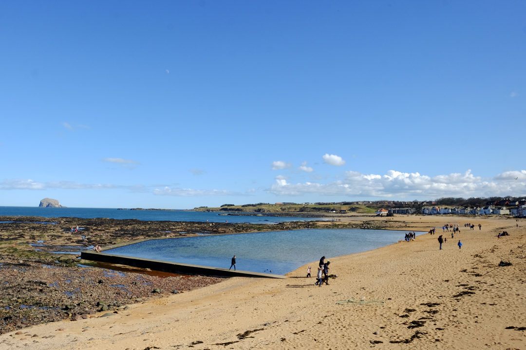
North Berwick
North Berwick is a brilliant wee seaside town with good independent shops and cafes, a working harbour, a fine beach, and a direct train to Edinburgh in 30 minutes.
Make sure you head down to the harbour to grab lunch from the Lobster Shack, a North Berwick institution.
The Scottish Seabird Centre on the harbour front is the best starting point for anyone interested in the wildlife of the Firth. Live cameras on Bass Rock and the Isle of May, knowledgeable staff, and boat trips to both make this a genuinely excellent attraction rather than just a visitor centre.
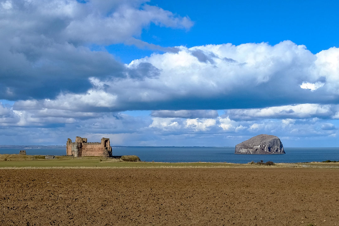
Tantallon Castle, three miles east of North Berwick, is one of the great Scottish castles, a fourteenth-century curtain wall fortress on a dramatic headland directly above the sea, with Bass Rock visible just offshore. The combination of the castle, the cliff, the sea and the rock behind it is one of the more spectacular views in Lowland Scotland.
Read more – plan a visit to North Berwick
North Berwick Law
Distance: 2 miles return | Grade: Moderate | Allow: 1.5 hours
The volcanic plug above the town is a short but rewarding climb with 360-degree views across the Forth to Fife, along the East Lothian coast, and inland to the Lammermuirs.
An Iron Age hillfort occupied the summit in prehistoric times. The whale jawbone arch at the top, a replica, periodically replaced as the original rots, is a North Berwick landmark.
The path from the car park takes 30–45 minutes up and is well-maintained.
North Berwick to Tantallon Castle coastal walk
Distance: 3 miles one way | Grade: Easy to moderate | Terrain: Coastal path, well-maintained
The path east from North Berwick along the John Muir Way passes above rocky bays with Bass Rock in view for much of the route. The castle ruins at Tantallon make a natural endpoint.
The walk can be extended to Seacliff Beach, a small privately-managed beach (small charge for cars) with excellent views back towards the castle and rock. Return the same way.
Tyninghame and the John Muir Country Park
The Tyninghame estuary east of North Berwick is quieter and less visited than Aberlady, with similar waders and wildfowl. Ospreys pass through regularly in spring and autumn.
The John Muir Country Park at Dunbar covers around 1,600 acres of coast including the Tyne estuary, dune systems and woodland.
It is the main green space of the East Lothian coast and excellent for longer walk, the circular routes through the dunes and along the shore take between one and three hours depending on how far you want to go. Harbour and grey seals are regularly seen along the shore.
Dunbar
Dunbar is at the eastern end of the East Lothian coast where the Forth opens into the North Sea.
John Muir, the founder of the American national parks movement and one of the most influential conservation thinkers in history was born here, and the John Muir’s Birthplace Museum on the High Street is a thoughtful and well-designed museum.
The John Muir Way, a long-distance coastal route, starts here and runs 134 miles to Helensburgh on the west coast; the East Lothian sections are among the finest coastal walking in Scotland.
The Dunbar Harbour is still working. The ruins of Dunbar Castle are built into the harbour walls, the sea washing around their foundations at high tide.
The Firth of Forth Islands
The Isle of May
The Isle of May is a National Nature Reserve five miles offshore from Anstruther and the most important seabird island in the Firth of Forth. In spring and early summer it holds around 100,000 nesting seabirds including puffins, razorbills, guillemots, shags, kittiwakes and eiders.
The puffin colony alone numbers around 40,000 pairs, nesting in such density along the clifftop paths that you have to watch where you put your feet.
Getting there: Day trips from Anstruther Harbour, April through early September. Book ahead, the May Princess run by Anstruther Pleasure Trips fills quickly in May and June. Crossing time approximately 45 minutes. Allow 2–3 hours on the island.
Best time: Late April through early June for puffins at peak. Grey seals pup on the island in autumn.
Tip: Go midweek if you can. The island is significantly quieter, and you’re more likely to get time alone with the puffins.
Read more – the complete guide to seeing puffins in Scotland
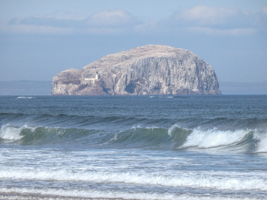
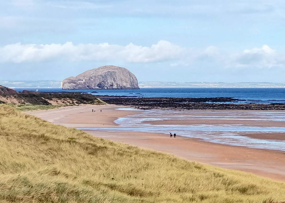
Bass Rock
Bass Rock is a volcanic plug rising 100 metres from the sea off North Berwick, it holds one of the largest northern gannet colonies in the world, around 150,000 birds in season. From a distance the rock appears white; that white is gannets covering every surface.
The rock also has a long human history: a medieval castle, a sixteenth-century chapel, and a spell as a state prison in the seventeenth century when Covenanters were held here in appalling conditions.
Getting there: Seasonal boat trips from North Berwick Harbour via the Scottish Seabird Centre. Book ahead in May and June.
Best time: April through August. Peak gannet activity is May and June.
Inchcolm
Inchcolm is the most accessible of the Forth islands and contains one of the best-preserved medieval abbeys in Scotland.
The Augustinian foundation dates to the twelfth century; the cloister, chapter house and tower are all remarkably intact.
The island also has Second World War gun emplacements, grey seals on the rocks below the cliffs, and puffins and guillemots nesting on the northern shore in summer.
Getting there: It is about 30 minutes from Edinburgh to South Queensferry by car, plus the boat crossing. The Maid of the Forth runs seasonal sailings from Hawes Pier, South Queensferry. Allow a full half-day.
Fidra
Fidra is a small RSPB-managed island visible from Yellowcraig Beach near Gullane. There are no public landings, but it can be viewed clearly from the shore or approached by sea kayak in calm conditions. A substantial colony of sandwich terns breeds here in summer.
Fidra’s association with Robert Louis Stevenson said to have inspired Treasure Island is debated but persistent.
Inchkeith
Inchkeith sits roughly mid-channel south of Kirkcaldy and is the largest of the formerly inhabited islands in the Firth. It has military fortifications from multiple centuries, an old lighthouse, and a history stretching back to at least the fourteenth century when it served as a plague quarantine station.
Inchmickery
Inchmickery is a tiny islet fortified in both World Wars. From the south shore it looks, with some imagination but not much, like a dreadnought riding at anchor. There are no regular public trips but it can be seen clearly from South Queensferry or Cramond.
Birdwatching on the Firth of Forth: a quick guide
Spring (April–June): Puffins, razorbills and guillemots on the Isle of May. Gannets on Bass Rock. Terns arriving at breeding colonies around the outer Firth. Migrant waders and passerines passing through in April and May.
Summer (June–August): Seabird colonies at full activity. Eider ducks with ducklings in East Neuk harbours. Dolphins — common and bottlenose — in the outer Firth following summer fish shoals.
Autumn (August–November): Migrant birds through coastal scrub. Skuas offshore. Pink-footed geese arriving from Iceland from mid-October onwards — sometimes spectacular passage over the Forth. Knot murmurations at Skinflats and Kinneil at high tide.
Winter (November–March): Waders on estuary mudflats. Long-tailed ducks, common and velvet scoter, and red-throated and great northern divers offshore. Whooper swans on coastal fields. Short-eared owls quartering rough ground near the shore.
Key sites: Aberlady Bay, Bass Rock, Isle of May, Tyninghame estuary, Skinflats, Kinneil, Fife Ness (sea-watching and migrants), Crail Harbour.
Where to stay
East Neuk, Fife: Anstruther and St Monans are the best bases for the Fife coast and Isle of May trips. Accommodation books up from May onwards, plan ahead.
North Berwick: The best base on the south shore for the outer Firth. Good range of hotels, B&Bs and self-catering. 30 minutes by train from Edinburgh.
South Queensferry: Small and atmospheric, under the bridges. Good for exploring both the upper Firth and the islands. Close to Edinburgh without being in it.
Dunbar: Good value, quieter than North Berwick, with easy access to the John Muir Country Park and the eastern end of the coast.
Getting around the Firth of Forth
A car gives the most flexibility.
The Edinburgh–Dundee rail line serves Aberdour, Burntisland and Kirkcaldy on the Fife shore; North Berwick has a direct line from Edinburgh Waverley (30 minutes); Bo’ness is on the Falkirk High line.
The Fife Coastal Bus connects East Neuk towns in summer.
The Forth Bridges link the two shores; the Kincardine Bridge is the alternative crossing for the upper estuary.
Kate — Love from Scotland x
You might also like:
- Things to do in Fife
- The best coastal walks in Scotland
- Where to see wildlife in Scotland
- Things to do in East Lothian
I’m Kate, the Scotland-based travel writer behind Love from Scotland. I share first-hand destination guides and accommodation recommendations across Scotland. Let me help you plan your best ever trip!